Difficulty: 3/5
Distance: 9.84 km
From: Tai O
To: Kau Ling Chung
Transportation:
- Take NLB No. 11 from Tung Chung going to Tai O, alight at the terminus and walk for 600 m to Nam Chung Playground to start
- Return by continuing Lantau Trail Section 8 to Shek Ping (4.65 km) to take NLB No. 11 back to Tung Chung
The distance post of this section of Lantau Trail ranges from L055 to L075. The start of the trail is beside the small playground, and you can also see a warning that part of the trail is not accessible because some villagers had blocked the trail. It is no longer an issue so you can proceed as usual.
The initial section is very easy, passing through the houses in Nam Chung before continuing on the concrete path along the seaside, to Fan Kwai Tong.
Afterwards the concrete path goes a bit into inland, and the sea is no longer visible, but still very flat and so you can proceed in a fast pace.
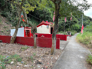
When you can see the well-maintained temple you are near Yi O. Originally I was worried that there are blockade which will force me to go back, but there is actually none in place.
Walking beside the shallow bay the path soon goes again to inland, and you can see the path going to the new village but we should continue to the old village.
There you will see some fields with vegetables growing, and I had a brief chat with the lady, who is friendly and checking where I was going. There was no hint of hostility that originally I fear, though the dogs are a bit fearsome coming out from the house when I approach.
Continuing along the coastline, passing by Tsin Yue Wan Campsite, the concrete path leads to Fan Lau, and you can see the pier and the Fan Lau Sai Wan beach.
A short distance you will enter Fan Lau Village, with a few houses and a branch. The trail will continue uphill at this point. But if you want to look at the Fan Lau Fort, Stone Circle and Stalagmite, then you have to go straight instead to Fan Lau Country Trail.
There are a few stores where you can get some supplies, but they may not be opened. Going now uphill you can take a good look at Fan Lau Tung Wan. This is the most challenging in this section, mainly because of the uphill and there is no shades, but the steps are well-paved.


沒有留言:
張貼留言