
Difficulty: 3/5
Distance: 7.84 km
From: Tseng Lan Shue
To: Sha Tin Pass
Transportation:
- Take KMB No. 91 departing from Diamond Hill Station heading to Clear Water Bay, alight at Tseng Lan Shue
- Return by walking down the stairs to Tsz Wan Shan (North) bus terminus, and take KMB No. 3M to Choi Wan
Date: 16 Dec 2021

This section of Wilson Trail has the distance post from W032 to W046. Beginning at Clear Water Bay Road, heads down to Tseng Lan Shue Village.

Then follow the signs which goes through the houses and soon will arrive at the trail leading into the woods.

The uphill trail begins with stone steps, and one unique reminder is that this area is very humid, and with the dense woods there is not much breeze. After a short while the trail begins to descend, and the trail has many tree roots sticking out, making it a bit challenging.

The forest trail is quiet, with a few streams on the way providing a bit of different landscape. The trail then comes to a branch, with the left going to Pak Fa Lam, so we turn right towards Ho Chung to continue on Wilson Trail.

Soon you will see one of the landmarks in this trail, an abandoned three-storeyed house. Some people would wander into the house, which still got some colorful window panes in place.

Continuing on the ancient trail are descending stone steps. While it might look a simple part, after rain the stones could be very slippery, so one must take extra caution on the walk down. Soon the trail comes to the end and joins the catchwater.

The concrete road serves as a break, but soon there is a branch on the left leading up. This also begins the most difficult part of this section, a tiring hike up to the hills.

On the way up, there are good views of Ho Chung and Nam Wai, which helps to provide some rewards on the ascend.

After the continual steps uphill, soon the path turns to pebbles, making the climb a bit more challenging.

Finally reaching the top of Tung Yeung Shan, the trigonometric station has been damaged, leaving only the base visible.

But here you can enjoy a wonderful panoramic view, on one side it is Ho Chung, and on the other side the continual hills towards Sha Tin Pass.

On the way down it is also quite challenging, with the slopes quite steep and no steps. Walking slowly and carefully, there are patches of silvergrass to take good photos in the winter time.


Continuing along the road, it begins to go down. After passing under the Tate's Cairn Meteorological Station, you will reach Jat's Incline Parking Viewpoint, offering another great views of Kowloon.

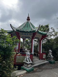
Finally reaching the end of this section, Lion's Pavilion. One can leave by walking down the steps to Temple Hill Kwun Yam Buddhist Temple to Tsz Wan Shan.
沒有留言:
張貼留言